December 09, 2010

An Iron Butt week on a little bike  


Two rides. The first Iron Butt Association Heaven to Hell 1000 and record attempt for the smallest bike to complete an Iron Butt CC50 (Coast to Coast in under 50 hours) on a Honda CBR 125
The route from Windsor, Ontario to Mt. Evans to Death Valley, to SanDiego California, to Jacksonville Florida

     In the middle of the desert in southern Arizona. Screaming over a hill at 11,000+ rpm. In the distance a police officer immediately uses his radar gun to paint the little white "crotch rocket" style motorcycle with the crouched down rider. He looks at the display and gets a very quizzical look on his face. After all, I’m not speeding, just trying to go as fast as possible on a bike of only 125cc. Welcome to the world of little bike Iron Butt riding.
This particular incident was four years in the making and started a long way away and with an entirely different motorcycle. I adopted, for free, a little 49cc Honda NS50F about 4 years ago and decided that since it had a genuine Honda two stroke racing (HRC) engine, it could be made to do Iron Butt Association rides. Of course the first thing that occurred to me was the way "CC50 on a 50cc" rolled off the tongue. I was hooked!

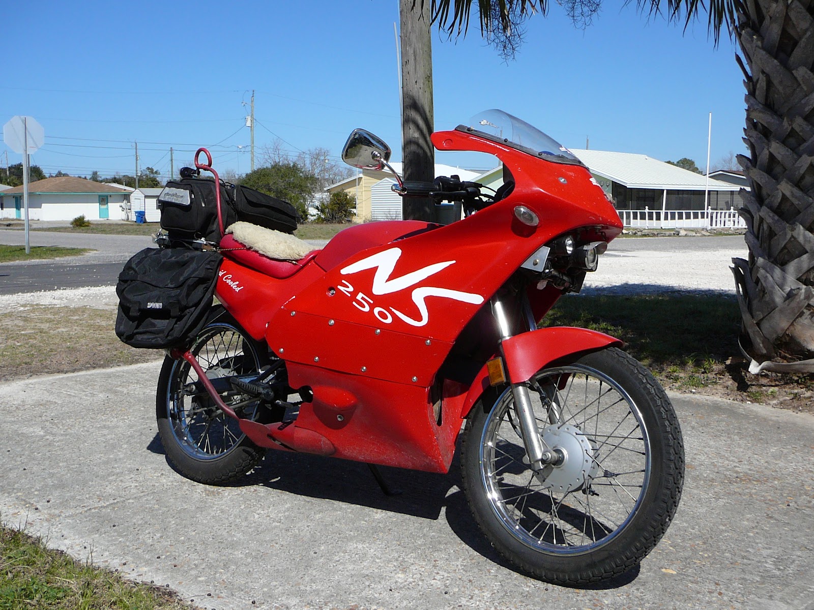
The 49cc Honda NS50 "Barbie Bike From Hell" (250 decals to help
with freeway restrictions :) )
     After completely rebuilding the bike with massive modifications to increase speed and equip it for long distance riding we actually completed some IBA rides on it. Most notably a "Bun Burner 1500" where it managed 1600+ miles in 33 hours. (See: http://bobmunden.blogspot.com/ click on 1600 miles, 33 hours, 49 cubic centimetres) Several rides later however it finally sunk in that even though it would do a 19 hour 1000 miles, it wasn’t fast enough to do a Coast to Coast in under 50 hours (IBA CC50) and still allow for delays and sleep.

     Thus after the Florida Legends ride in March of 2010 I decided to abandon a CC50 on a 50cc and just try for the small bike record for the coast to coast in under 50 hours ride.

     Since most of the planning etc. had already been done it was just a matter of a suitable bike. I managed to come across a new Honda CBR125 at a very attractive price. Can you imagine - it has a two year unlimited mileage warranty! So, the rush was on to modify it for distance riding, break it in, get going before it got too hot in the southwest and while the days were still long. All of the usual "Farkles" were applied. Fuel cell (4 gallons), GPS, light enhancement, hydration system, timers and clocks etc., etc. Thirty days later and a test ride of a Saddle Sore 1000 (1000 miles in under 24 hours) proved the little 125 could do the job. But could I? I started the usual regimen of exercises and abstinence of alcohol and caffeine.

The little 125 as ready as we could get it in a short time
      I had also been contemplating another ride which would dovetail with our trip out to the start in San Diego. I had been speaking to Mike Kneebone, (president of the IBA) and discussed a new ride. A 1000 mile route starting at the top of Mt. Evans (+14000 ft.) to the bottom of Death valley at Badwater Basin (282 ft. below sea leverl). This is from the highest point attainable by road to the lowest point, in the U.S.A. The ride was accepted as certifiable and the attempt was approved. The ride was later named by the IBA as the "Heaven to Hell 1000"

The usual crummy photo at O'dark Thirty at the Ambassador
Bridge in Windsor, Ontario
      So off we went at about 5:00 a.m. on May 27th, 2010. I met a riding partner, Charles Fider on his 1982 BMW R100RT (with 434,000 Km on it) at the Ambassador Bridge. After the obligatory photos - that as usual look terrible, we departed. A nice cool morning as we rode over the bridge to Detroit. With everything running smoothly it seemed just too good to be true. We decided to document the entire ride even though we would only submit for the two rides mentioned. Practice is always a good thing. After clearing Customs it was straight down to Toledo and then across the Interstate 90 toll road where we encountered the first glitch. My EZ-Pass failed to work. This really is a problem when the gate refuses to open and a voice comes out of the grill that sounds like an ostrich being strangled. I just kept yelling "I’ve got an EZ-Pass and it won’t work" over the tooting of horns behind. Finally the "Toll Troll" came by to manually punch in the number and off we went. The EZ-Pass that I’d lent to Charles of course worked perfectly. This scenario was to be repeated several times until past Chicago and blessedly no more toll roads. The ride however was great. Part of my test 1000 mile ride had been along this section of I-90 so there were no surprises.
     Overnight in the Lincoln, NB area made for a short second day. Early in day 2, along about the middle of Nebraska we stopped for some gas and water and I noticed that the bike hesitated when I tried to start it. Shortly down the road it just quit. No electrics at all. Fortunately the battery was still accessible with only a minimum of disassembly of add-ons. Turns out the battery cable screws had vibrated loose. Tighten them back up, add a dab of threadlock and we were back on the road in only about 15 minutes.

Charles working to find the electrical fault. Somewhere on I-80
in Nebraska

       This was a precurser of things to come. Threadlock, duct tape and zip ties seem to be the only cure for vibration. The rest of that day’s ride was generally as uneventful as the scenery in that part of the country. The only other issue was some bad gas just entering Denver which made for some tense moments causing speed drops down to 30mph on Denver freeways. Of course both the main and the auxiliary tanks were full of the stuff so all had to be drained. Even so we still had enough time to rest up for the trip up Mt. Evans on the next morning. We were trying to pace ourselves so as to not get exhausted before the main event(s).

     Checking in with the Mt. Evans Chief Ranger we were informed that the road had indeed been opened only the day before and should (weather permitting) be open for our attempt. We were also informed however that all of the area to the north of us had road closures due to snow. OOPS - time to look over our route and make some changes. We altered the route to continue on I-70 all the way to I-15 instead of taking a cut off up Hwy. 191. The additional mileage needed would be made up by going north on I-15 towards Salt Lake City, until the required distance was obtained and then finding a place to document a turn around to return wouthward.

     The attempt day dawned clear and cool so off we went. We were accompanied by Kenny Wayne on a Goldwing and Randall Briggs on a Harley, two fellow long distance riders who had ridden up from Colorado Springs to help witness our departure at the top.

Charles & Bob with the day's newspaper at the base
of Mt. Evans - Echo Lake in the background.
     We documented everything we could, hotel receipt, gas fill up, purchase at the base Mt. Evans store at the park entrance, the entrance fee receipt etc. The main difficulty of the ride other than simply riding a small bike over 1000 miles through some of the highest passes in the U.S. was the documentation. There is simply no way to get a "computer receipt" at either end. We even obtained a current newspaper and had our photos taken showing it, to document that we hadn’t done anything previously.
    The ride up Mt. Evans went surprisingly smoothly for such a small bike. Thank-you whoever invented fuel injection! The little bike didn’t so much as wheeze, although it was down into second gear on some of the sharp switchbacks.


High snowbanks carved out only a few days before.  Note crack in the
foreground.  The slope is steeper than appearances here.  Bob then Kenny,
Photo by Charles
 Once above the usual road problems at Echo Lake the climbing started in earnest. With very large 20 foot thick drifts above us with the road carved out of them it was daunting. Just thinking of all that bright warm (?) sunshine beating down on them we were quite expecting a snow slide. Fortunately none of us had any loud pipes saving our lives to set off an avalanche and we proceeded to the top unscathed. Once at the top we took the obligatory photos, met up with a Park employee as a witness and coerced anyone else around to witness our starting location. I believe we ended up with about six. Hopefully that will be enough.


Charles and Bob att top of Mt. Evans with Newspaper as part of documentation process.
     Once the paperwork was out of the way we were "on the clock" and therefore wanted to leave as quickly as possible. Since it was a balmy 36 degrees F. at the summit we were bundled up with all of our warm clothing on. Charles had the luxury of an electric vest but with the anaemic electrical system on the little Honda I was reduced to relying strictly on lots of clothing. The trip down the mountain was an absolute joy. All of the limitations of 125cc engine displacement disappeared as gravity took over. Wow - just like the big guys! At the bottom, reality again asserted itself and it was back to nursing the bike up hills and maintaining a racing crouch akin to trying to get under the paint. Surprisingly the little Honda was able to negotiate all of the hills and passes with a minimum of fuss. The lowest speed was in the Vail Pass area where steep hills along with the 10,662 foot elevation caused a drop only to about 53 mph. The extra tall gearing enabled me to keep going down in gears without dropping the speed to dangerous levels. Having Charles behind me and my wearing a reflective vest was comforting during slower portions. For the rest of the daylight hours it was a glorious ride through the Rocky Mountains. Cool weather up high and warmer at the lower elevations.
Into the Colorado Mountain Passes on the way West.  Charles getting a little "run" ahead.


Bob in his usual riding position somewhere in western Colorado
     All went smoothly until nearing the I-70 I-15 junction where we were to turn north. I hadn’t been able to find Charles in the rear view mirror for quite some time. This wasn’t unusual as he would occasionally take breaks from the tedium of following along. This was different however as I hadn’t seen him in over 15 minutes. I stopped for about 10 minutes at exit #1 (hwy 161) and waited about 15 minutes. Still no Charles. Of course I immediately went into panic mode and used the interchange to reverse my route and rode almost all the way back to Hwy 89. Still couldn’t find him. I stopped at a pull out and pulled up to an extra large tractor trailer that was running. After beating on the door for a few minutes a "extra large lady trucker" appeared at the window. I asked her if she had a CB and if so would she enquire if any trucks had spotted Charles. No luck. Deciding that I must have missed him I again rode west. As I approached Exit #1 again there was Charles waiting. He had came up just as I was negotiating the off ramp and decided to wait. He’d stopped to take a few photos. Phew! All my worries that the ride was over evaporated and we headed north under gradually darkening skies.
     As the sun went down, so did the temperature. By the time of our turnaround and gas stop at Scipio Out in Bad Standings it was in the middle 30’s. I thought that once we were again heading south as well as down in elevation that the temps would rise. No such luck. The dashboard thermometer seemed stuck at 36 degrees. This was my lowest point of the entire trip. I was uncomfortable and cold. Not a good combination. My only salvation was that the old IBA adage kept running through my head. "Keep finding reasons not to stop rather than reasons to stop". This kept me from pulling into a couple of rest areas but the last one north of Las Vegas was the hardest. I actually started slowing down. Then I found my reason - I would stop at the next one. The same reason I’d used for passing the previous rest area. But it worked. Within minutes the elevation started going down and the warmer desert air started to thaw out my numb body. By the time we turned at Las Vegas and stopped for gas it was a toasty warm 65 degrees. Heaven! I can’t believe I just said that about Las Vegas. When it’s cold and dark however your perceptions change.

Now we turned back north through the night and out into Death Valley National Park. Not having enough miles at the infamous "Nevada Joes"


The infamous Nevada Joe's where you could no doubt by anyone...err... I mean
anything.  Just before dawn and the temps are now bearable. Just north of  Death
Valley.  We checked mileage and found had to go to Beatty first for enough miles.
 we continued on and got another receipt at the little town of Beatty before descending into the valley of Death - so to speak. In actual fact the sun was just coming up and the temperature was a balmy 70 degrees F. More like Heaven than Hell. We were now in "get all the receipts you can" mode so we stopped at the automated ticket dispenser for Death Valley Park. You put in money and out comes a park pass. If you’re caught without one by a ranger you’re in trouble. Standing around looking at the scenery and letting ourselves rest for a moment at the pull off, all of a sudden there was a large crash behind us. Since we were the only ones here this was not good.


Entrance to Death Valley.  A few minutes later Charles' bike fell over with
a broken sidestand. Minor disaster! Major P.I.A.
Looking quickly around to see what was going on we found Charles’ BMW R100RT on it’s side leaking gasoline across the parking lot. Since he’d left it on the side stand this was definitely not a good thing. Picking it up we discovered that the sidestand had broken. As we righted the bike, Charles indicated that this would be a major problem. It turns out that the older BMWs don’t have a "ride off" type of center stand. Thus you had to get off and on without using anything to hold the bike up. With the fuel cell complicating matters it was nearly impossible to mount the bike and getting off was even more of a problem. Somehow he managed - sometimes with me holding it up and sometimes on his own. We continued on in a somewhat subdued mood and shortly arrived at the final check.

Badwater Basin, the lowest point in the United States at 282 ft. below sea level. The finish of the first "Heaven to Hell 1000". After taking the obligatory photos of the sign halfway up a large cliff announcing "Sea Level" we started to once again pester the other tourists for witness signatures.


Congratulatory Handshake. Photo taken by one of the witnesses.  The first Heaven to Hell 1000 is now complete
pending IBA certification. on a 125cc bike and an almost 30 year old bike with over 400,000 km on it!
The little white blob in the top center is the Sea Level sign denoting actual sea level it's some 230 feet above us!
      Since it was still early in the morning the tourist supply was limited but we managed a few good witnesses and decided that we might as well press on to San Diego. There is not a lot to do in Badwater Basin and the temp was steadily rising. What a surprise! 
There are some long lonesome roads in  Death Valley.  Just after sunrise and it is already about 80 deg. F.
     We had an interesting although uneventful trip across Death valley and had reasonable temperatures until turning south towards Los Angeles. As usual there was lots of traffic going around Los Angeles but it thinned out on the way southward.
     By the time we arrived in San Diego and booked into a Hotel close to the coast we were both very tired. So after a quick dinner it was sleep time.

      In the meantime, I had put out a plea on the internet to members of the Long Distance Rider’s network for assistance to find a welder for Charles’ bike and a source of a new back tire for the little Honda. Although the tire had looked fine at Death Valley the trip across the desert and the grooved pavement along the way had it now almost at the wear marks. This task wasn’t so easy as it was the long Holiday weekend and most places were closed. Fortunately, Craig Chaddock a local rider from the LD Riders list was not only able to find a Honda Dealer open on the holiday but set us up with a friend who has a race shop out of his garage. The Honda dealer had nothing to fit my 125 as that model is not available in the U.S.A. He did however have a front tire for a Ninja 250 but refused to install it on the back wheel of a bike. "Insurancedon’tchaknow" Was the reason. I bought it anyway and left with it around my neck "bandoleer style". Fortunately Craig’s friend Daniel Sherburne (DHS Racing) also has a tire change machine and could solve both of our problems.


Daniel (DHS Racing) changing the tire on the little Honda.
He also expertly welded up the BMW's sidestand.
      A most entertaining afternoon was spent bench racing and swapping stories while the BMW kickstand was expertly welded and my tire swapped by Daniel. I thought that having a tire for a Ninja 250 (the model that currently held the record of which I was attempting to break) was somewhat ironic. Once again early to bed for as much sleep as possible. Everything was finally a go!

     Our departure was to be timed to miss the San Diego rush hour so we had plenty of time for the trip down to the water to gather the traditional vial of Pacific Ocean Water. Once that was out of the way we were clear to get our beginning gas receipt at the gas station that seemed to be closest to the coast and we were now "on the clock" at 10:52 am Pacific Daylight Savings time. Headed east.

Beginning fuel receipt - we're now "on the clock" for
the ride from the Pacific to the Atlantic in under 50 hrs.

     Once out of the urban area surrounding San Diego the hills and desert of southern California exerted their usual summer welcome. Instant heat once away from the cool Pacific Ocean. Dry desert and hot. Much hotter than when we were in Death valley. We continued on and passed out of California into Arizona. At 3:52pm (all ride times are Pacific DST) our first gas stop was at Gila Bend, AZ. This generally set the trend for gas stops. About 4 1/2 hours. Generally just running out the fuel cells and using the main tanks as "reserve" Neither one of us wanted to run out of gas in the desert heat so we were extra conservative. During that afternoon my dash thermometer hovered between 106 and 118°F for several hours. Lots of water and few stops to get us out of the area of high heat as quickly as possible.
 
View crossing the deserts of Calif. and Arizona Temp 106 F.

     Generally a routine trip until darkness found us near Las Cruces, New Mexico. This was not a favourable position after a full day of riding and night falling. Lots of stories, newspaper articles and general fear mongering warned that stopping at a rest area and even some remote gas stops anywhere between Las Cruces and El Paso, TX was not safe. There have been many muggings and more than a little violence in the area due to robbery attempts by youth gangs. Charles readily agreed that we wouldn’t be stopping until well after El Paso, for any reason. Thus we rode on through the night and passed the infamous Ciudad Juarez as nothing more than a vast landscape of lights going over the horizon as we passed safely north of the Rio Grande river through El Paso, TX.

The Iron Butt Motel (AKA a Picnic table)  This is the delux
version with a roof and parking.  Keeps you away from
the fire ants and other critters on the ground.

An hour at the Iron Butt Motel in a rest area well to the east of El Paso set us up nicely for the rest of the night. With the dawn came relief at not seeing the herds of deer so commonly reported in west Texas. On through San Antonio (the aftermarket mirrors vibrated apart) and on to Houston (the aux. Laminar Lip windshield started to come off) we "duct taped" and "Zip Tied" our way into Louisiana. The toll was starting to tell after so many hours of high frequency vibration at such high RPM). After the long haul through Texas the smaller states seemed to be nothing more than the size of large cities. Our only slow down was through Louisiana near New Orleans where the bypass (hwy. I-12) was clogged with stop and go traffic that evening.

9:32pm necessitated another trip to the Iron Butt Motel. This time behind a gas station for 20 minutes. It never ceases to amaze me how much a short nap can refresh you. This one didn’t "take" however so about an hour later we stopped again, for a full hour this time. Fully refreshed it now felt like we were on the home stretch as we crossed the Florida border. Our last state and we were well ahead of schedule. Not far along however we decided to sleep for one more half hour just to make sure we were fresh for the boring run along northern Florida. It is after all mainly just a continuous forest.


Charles droning along in the early morning on I-10 - N. Florida

Daylight once again perked me up but about this time I noticed Charles starting to weave a little. This is not at all like him and I knew something was wrong. My big problem was that I couldn’t catch up to him to signal to pull over so we could talk. After several tries I managed to get close enough to catch his attention. We stopped at the next exit and both had an Egg McMuffin and a large black coffee. After not having any caffeine for over two months the effect was almost instant. The food also helped as I guess you can only get so much nutrition from Cliff bars every 41/2 hours and a handful of trail mix now and then. Not often am I accused of not eating enough. Lots of factors induce fatigue and lack of eating is a large one. Nearing the finish our spirits soared.


That all important "Off the Clock" receipt.

We knew the people waiting for us at the final gas stop in Jacksonville had been following the Spot tracking website so they would know when we would arrive. Imagine arriving and coming along the road from the south to see them eagerly peering north! A few beeps of the horn fixed that up as we hurried in to get a little gas and the all important "off the clock" receipt.

 
The final results 43h, 56m - not bad for a 125cc bike
      The photo of the GPS says it all .  Not a bad time for any size bike, and I can truthfully say that at no time were we within range of getting a speeding ticket (sob!). Hopefully our little week’s ride(s) will be certified by the IBA in the near future.

     These two rides complete a long time quest to do all three dimensions of the Contiguous states. Southernmost to northernmost (Bottoms Up Tour), west to east (CC50) and vertical (Heaven to Hell 1000) Several thing have definitely been proven however. Your bike doesn’t need to be big or new to do an Iron Butt ride. You can hold a modern (little) bike wide open at close to redline for over 90 hours in 6 days and it still runs great. "It is a lot more fun" as the old adage goes, "to ride a little bike fast than a big fast bike slow" With a little bit of planning an Iron Butt certified ride can be done on almost anything. So if you’re waiting for that new bike and "someday" you can just go ahead and do it now.

Many thanks especially to Charles who "droned" along to accompany me on this ride. Thanks also to my ever tolerant wife Lynn and my long time friend Ed Hooft and new friends Kenny Wayne and Randall Briggs. To the folks on the LD Riders list who always come through in a pinch when a member needs it and especially to LD Riders Craig Chaddock and Daniel Sherburne for their help in San Diego.


Here is a video of our final receipt stop at Jacksonville Beach. The not very affectionate greetings had to wait until we were off the clock once the receipt was printed. As you can see we look perfectly normal!

UPDATE: The Iron Butt Association has verified and approved both rides.  Here is the artwork they created for us and future riders that complete the Heaven to Hell 1000


Bob Munden
Windsor, Ontario
2010


This article in an very shortened edited format originally appeared in the Iron Butt Magazine Fall 2010 issue.

Some other rides recorded at: http://bobmunden.blogspot.com/

Photos of rides and bike prep. at: http:/community.webshots.com/user/bobmunden

Follow along on future rides via the "Spot" tracking system at: http://tinyurl.com/2akprnt

November 25, 2010

B.U.T. ride
"Bottoms Up Tour"
Notes on a ride from Key West, Florida to Angle Inlet, Minnesota:
The planning process over two years ago when I realized that no-one had done a sanctioned ride from the Southern most to the Northern most point in the contiguous United States. I wrote to Mike Kneebone, President of the Iron Butt Association. I asked if the I.B.A. would be interested in sanctioning such a ride if in fact it hadn’t already been done. Mike agreed enthusiastically and said "I have been wanting to use Angle Inlet for an IBA ride for quite a while, this is a great excuse to do so". With that encouragement planning started in earnest.
This route presents a few different challenges from the east/west coast to coast route even though they are almost exactly the same distance (within less than 50 miles difference). The North/South route has added complications due to variable route choices, a big difference in the choice of a start location (top or bottom), very different climatic conditions encountered and of course the remoteness of the Angle Inlet location. During the ride temperatures could reasonably be expected to range from high 90’s°F with correspondingly high humidity in the southern portions to close to freezing (or even possibly below freezing at the planned date) in the northern portion. In addition to having no "track records" of the ride route I myself was not familiar with the Northwest Angle of Minnesota area.

First was to research the unfamiliar. The internet proved invaluable in discovering that there was in fact a vibrant settlement at the northernmost point. Although it couldn’t be much more of a contrast to Key West and still be in the U.S. There is a road (of sorts) built in the 1980’s, and they actually got a land line telephone in the 90’s. I managed to contact some representatives of the community and found out that they do in fact have a "gas station" (tank is above ground as the frost keeps throwing it up every winter) with the ability to create a computer receipt for a finish time. They also have a State Trooper stationed there so perhaps an official finishing witness would be possible. After several phone calls to various people in the area I decided that the only way to be fully prepared would be to make a "reconnaissance" trip and see for myself just what conditions could be expected. Of special concern was the "dirt" road for the final 50 or so miles. My wife Lynn and I drove up in early April and found several interesting things. The road would driveable once the "frost boils" were gone (projected for early May) "so long as it wasn’t wet". (remember that phrase). The people were wonderful. We met "Trooper" Bob Nunn and his wife Sherri who agreed enthusiastically to be the finishing witness(s) and the "gas station" operator even showed me her house and which door to knock on to rouse her if I arrived late and the station was closed. All in all a successful and well worth it trip. By the way there was still snow in the bush and we counted 14 deer in the last 10 miles into the "Angle" as the locals call it. The other detail we wanted to check out was the border crossing. You see, you can’t actually get to the Northwest Angle from here.....sort of. Due to it’s unique location you have to either swim across Lake of the Woods or cross the border into Canada in the province of Manitoba go about 50 miles over paved and dirt roads then cross over the border again to get into Minnesota again and thus the "Angle". The border into Canada is straightforward although not what I’m used to home in Windsor/Detroit where literally 10 to 20 thousand people can cross daily. This is a two person affair which serves the highway as well as the railway line. The trains pull up just like a car and the officer walks over to talk to the engineer. I don’t know what they do for a passenger train as I only saw it happen with a (very long) freight train. The border from Manitoba into the "Angle" however is an entirely different situation. Picture a gravel/dirt road through the boreal forest. No houses, no traffic, no people, in other words wilderness. You know by the mileage that you’re nearing the border and are looking for the crossing. Whoops - you just missed it. Back up to read the sign. "Welcome To The United States, You are entering the Northwest Angle, Minnesota. Please report to the U.S. Officers For Inspection via the videophone at Jim’s Corner (8 miles ahead) Thank you for your cooperation Have a nice day." Sooooo.... we drove to the first cross road 8 miles down the road. Here you have two dirt roads crossing in the middle of the forest with a small mud turn off on one corner (raw bush on the other three) with a small plywood "phone booth" in it. Nothing so sophisticated as having a door even and it is absolutely no larger than a phone booth. Sort of looks like a very public outhouse. In it is a white box on the back wall with two buttons. One says "U.S.A." the other says "Canada". There is also a glass panel with a small camera lens visible behind it. The instructions are simple. Press the U.S. button if you’re going into (even though you’re already 8 miles in) the U.S. or press the Canada button if you’re going to go the 8 miles back to Canada. We pressed the U.S. button and were asked the usual questions then told that all was OK and would we stand in front of the camera and "if nothing happens in 30 seconds you’re free to go" We stood there for perhaps 2 minutes crammed both into the booth. All the time wondering what would be the alternative to "if nothing happens". Nothing happened. We left and that was that. So much for all the security and so forth. On the way out we found that the "Canadians" don’t have access to the Camera. Guess we really are a backward nation after all!
Further planning consisted of hours on the internet checking such things as weather averages for locations along the route at various times of the year, dates for the full moon, highway construction etc. etc. etc. etc.
Decision time. Decided to do the route from south to north. This was the major choice and was decided on by many factors such as: The ability to control the passage times through Miami and Atlanta so as to avoid traffic congestion. Since it would be early in the ride more control would be possible than if at the end of the ride where more delays would have had a chance to affect the planned time. The sun would be behind, rather than in front all day. The assurances of the people in Angle Inlet that they would accommodate a late arrival. Arriving at Key west at 3 a.m. could present problems. Other factors considered were time of departure (9:00 p.m.), date (May 23, so as to take advantage of the full moon, weather averages, and close to the longest daylight day of the year), getting the bike to Key West along with myself in a non exhausted state, what equipment, spares, food, hydration, adding a fuel cell to the bike and on and on and on......... the details seemed to crop up as fast as old ones were addressed. This was becoming quite a "Plan"
Decided to ride to Miami, leave the bike there and fly home for a week (work pressures/ rest up), fly back, pick up the bike, ride to Key West, stay (try to rest up some more) for a day and a half and leave on Sunday evening at 9:00 p.m. All went well on the ride down. Actually did a SS1000 (1000 miles in under 24 hours) from Windsor to Lake City, Florida. Must practice you know! Upon getting my final fuel receipt I found that the (now full) fuel cell was leaking all over the bike. More delays but got into Miami the next day. Nothing like riding down I-75 while sitting on a sheepskin in a puddle of gasoline. Fortunately that was only to the next town to find a bike dealer with a large enough wrench to turn the outside nut while I reached down into the almost full fuel cell to hold the inside nut. About this time I was beginning to wonder who was the nut, me or someone who had decided to not do this thing. I would appreciate your discretion in not offering advice or comments at this stage. In Miami I dropped the bike at a friendly Honda dealer for new tires and fluids and advised that I couldn’t pick it up ‘till next week as pre-arranged.
Flew home, flew back the following Friday and rode the bike from Miami to Key West. Got the required photos at the "Southern most Point monument". Collected my water sample from the ocean. Found a cop to sign my witness form. Tried to get some sleep and generally managed to avoid all of the temptations of Key West. This being off of caffeine and alcohol for a month prior to the ride was proving to be harder than at first anticipated. The caffeine was the worst. Around about 7:30 p.m. on Sunday I couldn’t wait any longer so went to the "southern most gas station" and again found it wouldn’t take a Canadian Visa card. This "please enter your Zip code" B.S. is getting really tiresome when you don’t have a Zip code. This first receipt therefore came from the inside machine - more were to follow.
Off at last. Weather hot and sun going down. Time to make some miles. Alas that was not to be. The highway from Key West to the Mainland hops along many small islands, each of which is a community in it’s own right. Every one of them had a radar trap. I’ve never seen such a concentration of speed law enforcement in my life. Where were these cops on my way down? Perhaps they just do this on a Sunday night to catch everyone after the weekend. Suffice to say that it was a long, slow and cautious ride the first 127 miles to the mainland. In general I don’t speed above the rate of the surrounding traffic flow on this type of ride since getting a ticket is slow and I find it isn’t safe to exceed the general flow of traffic. Not to mention that it’s tiring and the need for more frequent fuel stops. The main rule is "Arrive Alive - so safety plays a big part. Remember - the turtle won the race! Apart from the frustration of being delayed on the great adventure the ride "across the ocean" was delightful. The full moon (as planned) came up and it’s reflection across the water was truly magnificent. What an eerie feeling to be motoring along with nothing to see but ocean. It was almost like being in a boat as you could see across the water to other boats cruising along in the moonlight. This tranquillity soon was destroyed by clouds moving in over the moon and by Miami it was a steady rain and no more moon (not planned). All along the Florida’s Turnpike I smugly rode straight through the (seems like) hundreds of toll booths as I had obtained an electronic "Sun Pass" device which pays the tolls automatically from a small transcoder. The nice thing is they will take it back up to 48 days after purchase for a full refund. You still have to pay for the tolls however, but even they are at a reduced rate if you’ve got a "pass" (more planning).
Sunrise and onward to Atlanta. I had the benefit of lots of advice going through Atlanta regarding usage of the H.O.V. Commuter lanes by motorcycles. Let me say now that at 10:30 in the morning you don’t need them. Just follow I-75 right through the middle and do not slow down, go with the flow. The flow in this case was about 85+ m.p.h. in the inside lane, and sometimes more! Goodness knows what they were doing in the "fast" lanes. This proved to be the fastest part of the entire trip. Atlanta spit us out into rural Georgia into nice clear weather which lasted for most of the rest of the ride. Generally the rest of the ride until the planned sleep stop in Ottawa Ill (I-80 & I-39) was smooth apart from finding out that being an "Iron Butt" doesn’t mean that you actually have one - ouch!. Just watched the scenery unfold into the mountains of Chatanooga and area on into the rolling foothills then the flat lands of Illinois. Only glitch was getting sidetracked for 10 miles in a detour getting onto I-39 near Peoria. I still claim it was faulty signage and not my by then 25+ hours in the saddle with only a few 15 minute sleep stops at the "Iron Butt Motel" also known as a picnic table. Now if I could only discourage the "Hey are you OK mac" people when trying to catch a little rest. Next time I’ll have a large sign saying "I’m OK just sleeping" made and wear it. Checking into the Holiday Inn early in the a.m. provoked some sly looks from the clerk when I informed her I’d be checking out in 3 hours. I’m sure I heard the door lock into the office click as I went to my room for some very expensive sleep.
Aaaaaaaaa - shut it off - quick - Screaming Meanie ultra loud alarms are a real rude awakening. However they do, do the job. Not to mention setting off car alarms and rousing other guests at the end of the hallway. I left in a hurry. After all I had places to go. Another nice night/morning and later at sunrise was so impressed by the full moon (as planned) setting to the west as the sun rose in the east that I took the time to stop and take a picture. It actually looks like a sunset. One of my best photos ever. Onwards up through Wisconsin where at the higher elevations the leaves were still just buds on the trees. Down again to the bridge at Duluth, MN. Hot Damn, getting close, this ride might just be doable after all. Only about 6½ hours to go. The scenery is now beginning to change again and looks somewhat like southern Florida again. Generally flat with scrub brush and fields, strange to see.
Some 5 hours later arrived at the village of Warroad where the Canada/U.S.A. border crossing awaits. No problems with the customs folks although I’m absolutely sure he thought I was lying when I told him that I’d left Key West on Sunday night at 9:00 p.m., since it was now only about 1:00 p.m. Tuesday afternoon. While at the border it started to rain a bit. It had been looking threatening for the past couple of hours but this was still not according to plan. I departed the border and proceeded into Canada across Southern Manitoba towards the highway north back into Minnesota and Angle Inlet. Unfortunately the rain started up in earnest so lots of time was wasted trying to pull waterproof booties and gloves on over items already wet and "clingy". (not planned). Perhaps a little aside is in order here. My wife Lynn and her sister and brother were driving up from Windsor to meet me at the finish and then we were all to go for a slow ride home on a sort of mini vacation via Mackinac Island with the bike being a trailer queen. That was the plan anyway. In the mean time the rain is intensifying so I tried to make the best time possible on the "tar and chip" road leading up to where the gravel/dirt road would start. In about 50 miles I encountered one vehicle, a beat up black pick up truck. Which I passed. Finally after much trepidation I could see the road change colour ahead through the rain. The infamous dirt road which I had been assured would be no problem after the frost was out except when it is wet. Well it was wet, very wet, (not planned). The gravel had been pushed into rows alongside where the tire tracks had brought out nothing but mud! Smoooothe, slippery, like the inside of a diaper, mud. THIS WAS NOT PLANNED!!! Nothing for it but to slow down, way down. To crash now and not be able to finish would be heartbreaking, not to mention it would really have upset the Plan. So I wobbled my slow way through the forest as best I could. Honda Pacific Coast motorcycles are just about as far from a "dirt bike" as you can get and although she was trying her best, she just wasn’t very good as a "mudder" as they say about horses. Along about 20 miles into the dirt I noticed headlights in the gloom behind me. They seemed to be catching up fast. Uh-Oh! Surely this must be the old pick up truck I’d passed. Now he wants to exact revenge was my first thought. On closer looks (short looks as I was pretty busy) I noticed that it wasn’t a black truck at all. It was white and it looked like a van. Now that’s strange, cause I own a white van just like it and My wife is supposed to already be in Angle Inlet with it. After All she left on Monday morning and only had 1200 miles to travel. As it got closer my suspicions grew and as we turned a bend I saw it was towing a motorcycle trailer. My heart leapt. I wasn’t alone here in the mud and the rain. This was far better than any final greeting could have ever been. Just what I needed to help on the last stretch which was proving so difficult. (not planned but sure would have been if I’d thought such a meeting was plannable). Crossed the border (sign only) and sped turtle like the 8 miles to Jim’s Corners to clear customs back into Minnesota. Lots of hugs in the mud lot at the customs house, but I still wasn’t done. Unfortunately the phone was busy every time we pressed the U.S.A. button. We tried several times until a local came along and asked if we were getting a busy signal. "Yes", we replied, thinking it strange that he would guess this. "Its been busy for 3 weeks" he said. "Phone the number on the wall if you’ve got a phone." So that is how we cleared into the most secure country in the world. Standing in the rain, in a mud lot, talking on a cell phone.
The rest of the ride was somewhat of a blur. Time seemed to be compressed. Continue along the road into Angle Inlet and get gas at the store. The owner had my receipt waiting for me when I went in and was quite happy that he was to be a part of the ride. They remembered me from the reconnoissance trip, and were expecting me. DONE, DONE, DONE (as planned). Nothing to do now but to go to Trooper Bob’s and get the final official witness. Arriving at his house he and his wife came out in the rain to welcome me. Sherri said that she had just checked the map I’d given her previously and noted that my planned arrival time was 3:08 p.m. and that they wondered when they would see me. We all checked our watch at that time and had a good laugh. It was exactly 3:00 p.m. (almost as planned). "You’re actually 8 minutes early" stated Trooper Bob. I didn’t have the heart to tell him that I was actually an hour late (not planned) due to the time zone change. Went to find the cabin we had booked for the night and was officially welcomed by Lynn and Brian and Karen. Most trouble was finding something to put under the kickstand to prevent it sinking into the mud as my usual support just wasn’t large enough due to the mud created by all the rain. (not planned). Not to mention, of course, getting my creaky old non iron, butt off the saddle for the final time. Nothing more to do but to collect a water sample from the shore of northernmost point of land. Now I’ve got two simple bottles sitting on my mantle piece. One from the warm Ocean at Key West and the other from the icy waters of Lake of the Woods. Between them lies memories, lots of memories (as planned).
Bob Munden, Windsor, Ontario June, 2005

I'll add photos later